


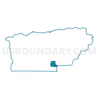
Voting District 50150, Tehama County, California
About
Outline

Summary
| Unique Area Identifier | 545221 |
| Name | Voting District 50150 |
| County | Tehama County |
| State | California |
| Area (square miles) | 28.66 |
| Land Area (square miles) | 27.78 |
| Water Area (square miles) | 0.88 |
| % of Land Area | 96.91 |
| % of Water Area | 3.09 |
| Latitude of the Internal Point | 39.90068300 |
| Longtitude of the Internal Point | -122.11201470 |
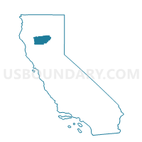
Maps

Graphs
Select a template below for downloading or customizing gragh for Voting District 50150, Tehama County, California


Neighbors
Neighoring Voting District (by Name) Neighboring Voting District on the Map
- Voting District 20160, Butte County, CA
- Voting District 40105, Tehama County, CA
- Voting District 40120, Tehama County, CA
- Voting District 40130, Tehama County, CA
- Voting District 50160, Tehama County, CA
- Voting District 50165, Tehama County, CA
- Voting District 50170, Tehama County, CA
Top 10 Neighboring County Subdivision (by Population) Neighboring County Subdivision on the Map
- Chico CCD, Butte County, CA (100,826)
- Corning CCD, Tehama County, CA (14,698)
- East Tehama CCD, Tehama County, CA (3,889)
Top 10 Neighboring Place (by Population) Neighboring Place on the Map
Top 10 Neighboring Elementary School District (by Population) Neighboring Elementary School District on the Map
- Corning Union Elementary School District, CA (14,641)
- Richfield Elementary School District, CA (1,193)
- Kirkwood Elementary School District, CA (297)
Top 10 Neighboring Secondary School District (by Population) Neighboring Secondary School District on the Map
Top 10 Neighboring Unified School District (by Population) Neighboring Unified School District on the Map
Top 10 Neighboring State Legislative District Lower Chamber (by Population) Neighboring State Legislative District Lower Chamber on the Map
Top 10 Neighboring State Legislative District Upper Chamber (by Population) Neighboring State Legislative District Upper Chamber on the Map
Top 10 Neighboring 111th Congressional District (by Population) Neighboring 111th Congressional District on the Map
Top 10 Neighboring Census Tract (by Population) Neighboring Census Tract on the Map
- Census Tract 11, Tehama County, CA (7,523)
- Census Tract 10, Tehama County, CA (7,175)
- Census Tract 14, Butte County, CA (5,797)
- Census Tract 9, Tehama County, CA (3,678)